i-gotU gt-120 GPS Logger Review

February 24th, 2010

Since this summer I’ve been using a little GPS logger to record some of my mountain bike rides and hikes. It’s the i-gotU gt-120 GPS Logger from Mobile Action. As you can see in the photo above it’s very small.

Unlike the Garmin Edge 705 that I have for navigating and seeing my speed, distance, etc. while I’m riding, the GPS logger just records for download after the ride. Since I have the Edge 705 you may wonder why I’d use both. I received the i-gotU from Mobile Action so I could review it and ended up finding it very useful.

Since it’s water resistant, I’ve been just throwing it in my jersey pocket or hydration pack along with whatever else I’m carrying. It has a blue rubber bumper that fits around it to help cushion impacts. I haven’t taken any hard falls with it but it’s held up well bouncing around in my pocket.

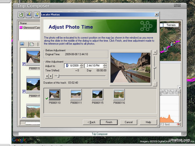
It’s designed as a travel logger so you can share your adventures. The software that comes with the GPS logger makes it easy to geotag photos you take. If you aren’t familiar with geotagging, it adds GPS coordinates to photo files so services like Flickr can place them on a map.

It’s best to have the time set correctly on the camera since the software places the photos based on time. Even if the time isn’t set correctly, the software that comes with the gt-120 provides an easy way to adjust the time. If you know the time difference, you can enter it or you can drag the slider until it shows the photo in the right spot on the map.

Once photos have been added, you can then easily upload the map and photos to the web. They provide some space free on their @trip site and then you can buy additional space. Photos can be uploaded to @trip, Flickr or Picasa.

Once you’ve uploaded the map, you can share the link with friends or embed the map on your blog as you see below. You can also save the trip to file as a web page in .mhtml format or the Google Earth files as .kml or .kmz. When the map is uploaded to their website, they significantly reduce the number of waypoints so you don’t get as accurate of a route as you get saving it to file.

For me, saving to a Google Earth file is very useful. I used to need a couple software programs to create a map with photos of my rides. Now with the GPS logger and software it’s easy. I do have to do a bit of editing so the paths are right when I put it online. I made this Pueblo Reservoir map using the gt-120 and software.

The gt-120 has plenty of storage with 64,000 waypoints. It can be configured to store a waypoint every second or every several minutes and anything in between. There’s a setting to have it log at a different interval if your speed is higher than a set amount. I’ve been using mine with it set to log every 6 seconds. If my math is correct, that would mean I can store over 100 hours of data before it fills up.

How often a waypoint is saved also affects how long the battery lasts. With it set to log it estimates the battery will last 10 hours. I’ve used it a little longer than that without a recharge without a problem. Setting the logging interval to 12 seconds, gives an estimate of 30 hours of battery life.

The i-gotU GPS logger also is designed to work as a GPS receiver for navigation software. I haven’t tried using it that way so don’t know how it works.

i-gotU gt-120 GPS Logger Likes

  • Small Size
  • Easy to geotag photos
  • Easy to share adventures
  • Reasonably accurate even when in jersey pocket or outer pocket of pack

i-gotU gt-120 GPS Logger Dislikes

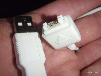
  • Charging and downloading data require a special USB cable. It’s probably used to keep dirt and water from getting in port.

  • Blue and red lights that indicate whether the logger is on, locked on satellites, etc. are very hard to see in sunlight.
  • The only charger is the USB cable so you need a computer or an adapter to charge it.
  • Some parts of the software aren’t intuitive

i-gotU gt-120 GPS Logger Specs

  • Dimension: 1.75 x 1.1 x 0.5 inches
  • Weight: 0.7 oz
  • Built-in SiRF StarIII 65nm low-power chipset
  • Built-in GPS patch antenna
  • Built-in flash memory
  • Built-in 230mAh Lithium-ion battery
  • 2 LED for tracking and battery/charger status indication
  • USB 1.1 interface for PC connection
  • Operation temperature: 15 to + 120 degrees Fahrenheit

UltraRob

Scarpa Zen Pro Mid GTX Hiking Boots
Price: $159.94
 
Hi Tec Penrith Mid Jr. WP Hiking Boots
Price: $38.73
 
Adidas AX2 Mid GTX Hiking Boots
Price: $135.00
 

New Garmin Edge 500 Cycling GPS

September 2nd, 2009
Garmin Edge 705 vs Edge 500
Garmin Edge 705 vs 500 (from Jake’s Journal TwitPic)

Yesterday Garmin announced a new cycling GPS. The new unit is called the Edge 500. It was designed based on feedback from Team Garmin. It will give competitive cyclists the information they need while training and racing without weighing them down.

It weighs much less and is more aerodynamic than the Edge 705. It also looks much smaller than the older Edge 305. It uses a new mount that is low profile and appears easy to swap from one bike to another.

The Edge 500 also works with the Garmin ANT+ heart rate monitor strap and cadence/speed sensor. It also works with 3rd party power meters that support ANT+. They claim that there’s improved calorie counting when using heart rate. That would be nice but I’m skeptical since I’ve never seen any calorie counting that seemed anywhere close at least for me.

The Edge 500 doesn’t include the maps and routing of the Edge 705. It also doesn’t include the ability to setup workouts like the 705.

The MSRP for the Edge 500 is $249.99 by itself and $349.99 when bundled with a heart rate monitor strap and speed/cadence sensor. That’s not a bad price considering just downloadable Polar cycling heart monitors cost nearly that much not many years ago.

Related Links

UltraRob

Scarpa Zen Pro Mid GTX Hiking Boots
Price: $159.94
 
Hi Tec Penrith Mid Jr. WP Hiking Boots
Price: $38.73
 
Adidas AX2 Mid GTX Hiking Boots
Price: $135.00
 

Garmin Edge 705 Tip – Save Last Ride and Reset

March 17th, 2009

Garmin Edge 705 GPSThe downloadable bike computer I’ve used in the past would create a new ride if I stopped recording and then restarted. I figured the Garmin Edge 705 would work the same way. I have found out that this is not the case. In fact turning the unit off and back on does not create a new ride.

When I connect it to the computer with the USB cable, it shows that it is saving history. I want to save all of my rides but I don’t want to connect it to the computer after each ride.

After searching around, I found that pressing the lap button for a couple seconds saves the current ride and resets the miles, vertical feet, etc. A little box pops up that says resetting data and counts down 3..2..1.

Scarpa Zen Pro Mid GTX Hiking Boots
Price: $159.94
 
Hi Tec Penrith Mid Jr. WP Hiking Boots
Price: $38.73
 
Adidas AX2 Mid GTX Hiking Boots
Price: $135.00
 

Technorati Tags: | | |

Garmin Edge 705 Review – First Impressions

March 2nd, 2009

Garmin Edge 705 Mounted on Mountain Bike

A few weeks ago I purchased the Garmin Edge 705. Since then I’ve been using it on my mountain bike. I haven’t set it up on my road bike but neither have I ridden my road bike the last few weeks.

The Edge 705 comes in 3 different bundles. The Edge 705 basic bundle includes GPS and heart rate. The next Edge 705 bundle adds cadence and wheel sensor. The deluxe Edge 705 bundle also comes with street maps.

What's in the Garmin Edge 705 BoxI got the Edge 705 package that includes the cadence and speed sensor but without the street maps. The street maps that come in the bundle are on the microSD card. I decided to get the MapSource DVD version of the City Navigator so I can also use it on my computer. In addition I got the detailed 24k topo maps for Colorado and Utah on a microSD card.

So far I’ve used it mainly as a bike computer and heart rate monitor. Not having a separate heart rate monitor is very nice. The GPS adds nice functionality to the cyclocomputer such as not needing to figure out the wheel size. Also the barometric altimeter adjusts itself automatically. I’ve had a altimeter cycle computer since 2002 and I was always trying to figure out the elevation before riding when I was traveling.

Red Rock Canyon Open Space Mountain Bike RideThe only thing I’ve done so far with the GPS is download my tracks. Having the route is cool but I think some of the other GPS features will be even cooler. The Edge 705 lets you set a waypoint and use the GPS map and the 705’s turn-by-turn directions to find your way back. You can save any ride in your history file and compete with yourself later by calling it up from the history file. You can show up to a group ride with a route and share it wirelessly with other Garmin units.

Look for a more detailed Garmin Edge 705 review in a month or two when I’ve had more time to explore it’s features. I’ll also be trying it with some of the available GPS software and websites. So far I’ve just barely used the Garmin Training Center and TopoFusion. Here’s a list of GPS sites that I’ll potentially try out.

With my limited use of the Edge 705, here are some of my likes and dislikes.

Garmin Edge 705 Likes

  • It can display up to 8 pieces of information at once. I’m currently displaying ride time, speed, distance, time of day, elevation, heart rate, total ascent and cadence. Even with that much information, I can see it easily.
  • The Edge 705 was very easy to install and start using. The heart rate monitor and speed/cadence sensor need to be paired but that’s done at the factory if you buy them in a bundle. The GPS unit detected mine within a couple seconds of turning it on.
  • The heart rate monitor strap is more comfortable than the Polar T61 strap I’m used to. My guess from wearing it on my first ride was that the Garmin one was narrower. I compared the 2 and the Garmin strap is actually slightly wider in spots. The difference is it’s much more flexible and softer than the Polar one.
  • The heart rate has picked up reliably without any wild fluctuations.

Garmin Edge 705 Dislikes

  • I have the auto-pause feature turned on and it thinks I’m stopped when I’m not. At first I thought maybe the wheel sensor wasn’t close enough but I adjusted it and that doesn’t seem to be the problem. It seems the Edge tries anticipating my stops. When I brake hard coming into a corner or before going over a drop, it seems to decide I’m going to stop. It’s not a big deal because it resumes immediately but the beep it makes gets annoying.
  • The Garmin Trainer Center isn’t included on the disk in the box. The only thing on it is documentation. I would like to see software shipped in the box and then have easy update functionality for it.
  • The Edge requires USB drivers to be installed. The documentation says the drivers are on the disk but I couldn’t find them. The drivers do get installed with Training Center but I first tried using it with TopoFusion. The Garmin USB drivers can also be downloaded from the Garmin website.
  • When I’m riding technical sections, I worry I’ll crash and destroy the Edge 705. I think I need a rollbar cage over it to give me peace of mind.

Related Link: Garmin Edge 705 Tip – Save Last Ride and Reset

Edge 705 Specs from the Garmin Website

Physical & Performance:
Unit dimensions, WxHxD: 2″ x 4.3″ x 1″ (5.1 x 10.9 x 2.5 cm)
Display size, WxH: 1.37″ x 1.71″ (3.48 x 4.36 cm); 2.2″ diag (5.6 cm)
Display resolution, WxH: 176 x 220 pixels
Weight: 3.7 oz (104.9 g)
Battery: rechargeable li-polymer
Battery life: 15 hours, typical
Water resistant: yes (IPX7)
GPS-enabled: yes
High-sensitivity receiver: yes
RoHS version available: yes
Maps & Memory:
Basemap: yes
Ability to add maps: yes
Accepts data cards: microSD™ card (not included)
Lap history: 1000 laps
Waypoints/favorites/locations: 100
Routes: Limited by memory space available
Features:
Heart rate monitor: yes
Bike speed/cadence sensor: yes (some versions)
Foot pod: no
Automatic sync (automatically transfers data to your computer
):
no
Garmin Connect™ compatible (online community where you analyze, categorize and share data): yes
Garmin Training Center® software compatible: yes
Virtual Partner® (train against a digital person): yes
Courses (compete against previous workouts): yes
Auto Pause® (pauses and resumes timer based on speed): yes
Auto Lap® (automatically starts a new lap): yes
Auto Scroll (cycles through data pages during workout): no
Multi-sport (changes sport mode with a press of a button): no
Advanced workouts (create custom, goal-oriented workouts): yes
Simple workouts (input time, distance and calorie goals): yes
Pace alert (triggers alarm if you vary from preset pace): yes
Time/distance alert (triggers alarm when you reach goal): yes
Interval training (set up exercise and rest intervals): yes
Customizable screen(s): yes
Barometric altimeter: yes
Unit-to-unit transfer (shares data wirelessly with similar units): yes
Power meter compatible (displays power data from compatible 3rd party ANT+™-enabled power meters): yes
Sport watch: no
Additional: Operating temperature: -15°C to +50°C

Scarpa Zen Pro Mid GTX Hiking Boots
Price: $159.94
 
Hi Tec Penrith Mid Jr. WP Hiking Boots
Price: $38.73
 
Adidas AX2 Mid GTX Hiking Boots
Price: $135.00
 

Technorati Tags: | | |

Bike Ride Mapping with GPS

November 24th, 2007

Over a few weeks, RoadBikeRider listed several ways to do map bike rides in their newsletter. They first mentioned MapMyRun. Readers then sent them better ways to map for cycling. I know my friend always sends me links to MotionBased when he does big rides.

I’m really not a gadget kind of guy. I don’t have a GPS unit other than the one given to me for Race Across America. It doesn’t have an interface and has to be used with mapping software on a computer.

I don’t have any computer on my mountain bike and for a long time I didn’t even have one on my road bike. In 2002 when I started riding more on the road and getting ready for my first RAAM qualifier, I started doing the UMCA Mileage Challenge. Now it’s called the UMCA Year-Rounder Challenge. One of the ways to submit personal rides is to use a downloadable computer. I got the downloadable CM414 which has an altimeter so I can see the profile of my rides.

One of the things I’ve been concerned about with GPS units is that I hear they typically only have a 10 hour battery life. I’ve heard that at least on some of them you can swap batteries and not lose the current route so maybe that’s an option. Another reason has been that I didn’t want to spend the money. I figured in another year I’d get something better for less money. Now I’m thinking they might be getting close to something I’d pay for. If you use a GPS, what do you like or not like about yours?

Here’s the ways to use GPS to map rides that RoadBikeRider readers sent in.

TopoRoute doesn’t require clicking multiple times to go around a curve. It has logic to follow the road. For bike paths and shortcuts that aren’t roads, it allows you to “not follow the road.” It also has an elevation feature. You can even create a link to your route and e-mail it to friends. — Kurt J.

Bikely uses Google maps. It’s got some great features including an elevation chart. I’ve been using it for years. — Cory B.

MapMyRide lets riders save their routes and e-mail them to friends or post them on the Map My Ride website for access by the internet community. This could be a good source for finding a decent route when visiting an unfamiliar area. A route can be uploaded to Google Earth to overlay it there. — Bob B. www.mapmyride.com has a “follow roads” option where you don’t have to put lots of points around curves to get accurate results. — Mike E.

VeloRoutes offers GPX and Google Earth export plus auto-routing, a feature that makes the route lines “snap” to the road. — Matt M., veloroutes creator

RouteSlip has many routes mapped out and also includes elevation profiles. — Tracy G.

CyclistNexus is very much a work in progress but there are some awesome features. You can track weekly mileage, favorite routes, weekly elevation gain and heart rate info. Plus you can plan out events and group rides. Keep an eye on it. — Tim A.

Google Maps. I like Google maps. They can automatically follow the corners for you. Google also gives turn-by-turn written directions for those who are map-reading challenged. Unfortunately the time estimates are off since it assumes you will be traveling at the speed limit. It also doesn’t give you an elevation profile. Here’s the route of a recent 78.5-km ride. — Michael N.

Gmaps Pedometer can use a hybrid view of satellite with street names. When your trusted Cateye computer is on the fritz then you can count on this site to count your miles. — Bob S.

These were sent in (with comments) by Rob A. of Webster Groves, Missouri.

  • RouteSaver. An application that can be used to save any of kind of running, cycling or other route. The tool is based on the new interface that Google has provided for its Google Maps program.
  • MotionBased is a web application that translates GPS data into functional analysis and online mapping for athletes. Affiliated with the Garmin GPS company.
  • My favorite is Trimble AllSport GPS. It’s designed to run on GPS-enabled cell phones and in web browsers, combining global positioning technology and mobile communications. It’s free and works great with my Garmin Forerunner 301. Here’s an example ride.

Fernando M. also wrote to them and said, “I’m surprised no one offered up Bike Route Toaster as one of the best mapping sites out there. It allows you to download in numerous formats and even saves your rides online.

Scarpa Zen Pro Mid GTX Hiking Boots
Price: $159.94
 
Hi Tec Penrith Mid Jr. WP Hiking Boots
Price: $38.73
 
Adidas AX2 Mid GTX Hiking Boots
Price: $135.00


Email: web@ultrarob.com

Business Seal       Privacy Seal