|
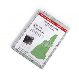
The National Geographic's Trails Illustrated folded map of the White Mountains: Franconia NotchLincoln. Designed to take you into the wilderness and back. Waterproof and tear resistant material with a plastic coating that offers supreme durability. Measures 4 x 9 inches folded and 37.5 x 25.5 unfolded scale 1:63,360. Shows trails, campsites, recreational features, plus relevant info on wildlife, history, geology, archaeology. White Mountain National Forest, Pemigewasset, Sandwich Range wilderness areas, Appalachian National Scenic Trail: Hanover to Crawford Notch State Park. Franconia Notch State Park, Echo Lake State Park, Kancamagus Highway, Tripoli Road, Bear Notch Road, and more.
|


 Blog Feed
 Follow on Twitter
 Become a Facebook Fan
 Flickr
 MySpace