|
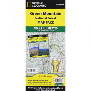
Green Mountain National Forest White Rocks National Recreation Area / Manchester Trails Trail MapTwo National Geographic Trails Illustrated maps for Green Mountain National Forest 747 and 748 offer the most detailed and up to date map for the area. Each map contains easy to read trails, numbered forest service roads, campsites, access points, scenic and historic points of interests, and important facilities. The carefully researched maps are developed in cooperation with local land managers and agencies. Green Mountain National Forest covers more than 400,000 acres that stretch across nearly two thirds the length of Vermont.Coverage Highlights: Breadloaf, Bristol Cliffs Joseph Battell Wilderness Areas, Big Branch, George Aiken, Glastenbury, Lye Brook Peru Peak Wilderness Areas, Long Trail National Recreation Trail, Robert Frost Interpretive Trail, Connecticut River Byway, Moosalamoo National Recreation Area, Middlebury Gap Scenic Route, state parks, ski areas, heritage sites, winter recreation and sports areas, hiking trails, mountain biking, campgrounds, fishing, cross country skiing and support centers, overlap with Trails Illustrated White Mountains coverage, and much more.
|
| Merchant | Price | Regular Price | |
|---|---|---|---|
| CampSaver.com | $10.76 on sale | $11.95 |
Copy the following string into an e-mail to support@ultrarob.com to request support.
Mozilla/5.0 AppleWebKit/537.36 (KHTML, like Gecko; compatible; ClaudeBot/1.0; +claudebot@anthropic.com)
 Blog Feed
 Follow on Twitter
 Become a Facebook Fan
 Flickr
 MySpace