|
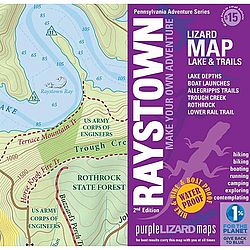
Raystown Lake Trail MapThe newest lizard map picks up where Rothrock ends, in Huntingdon, PA, and goes south all the way to Saxton. It includes all of Raystown Lake with a detailed map of the Allegrippis Trail System and Trough Creek State Park. PRODUCT FEATURES: RAYSTOWN , Purple Lizard Raystown Lake Trail Map , trail map , maps , road map , RAYSTOWN LAKE , Huntingdon , Pennsylvania , trail guide , hiking , mountain biking , allegrippis trail
|
Copy the following string into an e-mail to support@ultrarob.com to request support.
Mozilla/5.0 AppleWebKit/537.36 (KHTML, like Gecko; compatible; ClaudeBot/1.0; +claudebot@anthropic.com)
Email: web@ultrarob.com
 Blog Feed
 Follow on Twitter
 Become a Facebook Fan
 Flickr
 MySpace
Similar Gear
| ||
| ||
| ||
| ||
|