|
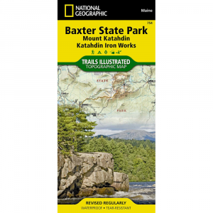
National Geographic Trails Illustrated Baxter Peak / Mount Katahdin / Katahdin Iron Works METhe National Geographic Trails Illustrated Map of Baxter State Park including Mount Katahdin the greatest Mountain Katahdin Iron Works is essential for any trip to the north Maine woods. This easy to read map shows the northern terminus of the Appalachian Trail, KI JO Mary Forest, Katahdin Iron Works, The Roach Ponds and Maine Parks Public Reserved Lands. This 2 sided map, one side is North and the other is South. It is printed on water proof, tear resistant paper. Printed in multi colors for your map reading ease and enjoyment. This map contains easy to read trails, numbered forest service roads, campsites, access points, scenic and historic points of interests, and important facilities. These carefully researched maps are developed in cooperation with local land managers and agencies. GPS compatible with full UTM grids. Coverage Included: Northern Terminus Appalachian Trail, Katahdin Iron Works, Roach Ponds, the Allagash Wilderness Waterway, Camping and fishing in Baxter Park, Info on Baxter State Park, and info on the North Maine Woods Inc. Stewards of the Maine Woods Shows Visitor Centers, Info Stations, Camp Grounds, Primitive Canmpsites, Picnic areas, AT Shelters and much more The Baxter State Park Mount Katahdin map is printed in the U.S.A. on a durable synthetic paper, making it waterproof, tear resistant, and trail tough capable of going anywhere you do. Net proceeds from the sale of this map go to support the non profit mission of the National Geographic Society. Info on hiking in Baxter Park included Waterproof 2 sided Tear resistant paper Includes complete area and emergency info LatitudeLongitude, UTM, and Magnetic Declination for use with GPS and Compass Dimensions Folded size: 4.25 x 9.25 Unfolded size: 37.5 x 25.5 Scale: 1:63,360 1 1 Mile Contour Interval 50 feet Year 2011 ISBN 9781566955850 GPS compatible with full UTM grids.
|
Copy the following string into an e-mail to support@ultrarob.com to request support.
Mozilla/5.0 AppleWebKit/537.36 (KHTML, like Gecko; compatible; ClaudeBot/1.0; +claudebot@anthropic.com)
 Blog Feed
 Follow on Twitter
 Become a Facebook Fan
 Flickr
 MySpace