|
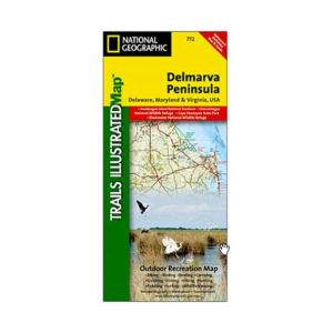
The new Delmarva Trails Illustrated covers all major recreation areas for the Peninsula and Chesapeake Bay region. Includes all state parks, state wildlife areas, national wildlife areas, and key recreation access points. Highlights include: Blackwater and Chincoteague National Wildlife Refuges Assateague Island National Seashore Cape Henlopen State Park. Displays locations for camping, boating, canoeingkayaking, hunting, bikinggreenways, and fishing. Includes UTM grids for use with your GPS unit. Dimensionsfolded: approximately 4 14 x 9 14 in.. Dimensionsfully opened: 25 12 x 37 34 in.. Scale 1:250,000. Map revised: 2004
|


 Blog Feed
 Follow on Twitter
 Become a Facebook Fan
 Flickr
 MySpace