|
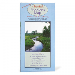
Adirondack Paddler MapThe Adirondack Paddler's Map is a waterproof, full color shaded relief map showing portages and campsites for canoe and kayak travel. 1:50,000 scale. Covering The Saranac Lakes, St. Regis Wilderness Area, Santa Clara Tract, Five Ponds Wilderness, Whitney Wilderness, Raquette River, Cranberry Lake Wild Forest. Measures 9 x 5 inches. Weights 5.5 ounces.
|
Copy the following string into an e-mail to support@ultrarob.com to request support.
claudebot
Email: web@ultrarob.com
 Blog Feed
 Follow on Twitter
 Become a Facebook Fan
 Flickr
 MySpace
Similar Gear
| ||
| ||
| ||
| ||
|