|
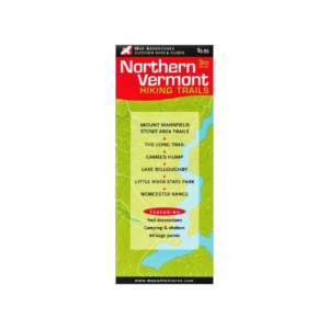
Updated with new GIS database and expanded to include Stowe Village Trails, the Northern Vermont Hiking Trails map from Map Adventures is northern Vermont's most popular hiking map. . Contains both family friendly and challenging hikes and highlights some of the best kept secrets in VT. Areas covered: Mt. Mansfield, Stowe Village, Smugglers Notch, Camels Hump, the Worcester Range, Lake Willoughby, Cotton Brook, Little River State Park, and Mt. Elmore. Includes the Long Trail and Catamount Trail. Provides information on camping shelters and tent sites and mileage between points. Scale 1:26,000. Third edition published by Map Adventures. 19.5 x 27 in.
|


 Blog Feed
 Follow on Twitter
 Become a Facebook Fan
 Flickr
 MySpace