|
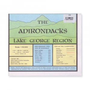
Adk Lake George Region MapThis massive 35 x 45 in. topographic trail map details the area from Whitehall to Lake George to Warrensburg to Stony Creek up to North Hudson, Crown Point, and Ticonderoga. Includes Lake George, Schroon Lake, Brant Lake, Paradox Lake, Eagle Lake, Pharaoh Lake, lower Lake Champlain, and part of the Hudson River. Scale: 1:62,500 contour interval 20 ft.. Lightly treated with a water resistant coating. Copyright 1984.
|
| Merchant | Price | Regular Price | |
|---|---|---|---|
| Eastern Mountain Sports | $6.00 | $6.00 |
Copy the following string into an e-mail to support@ultrarob.com to request support.
Mozilla/5.0 AppleWebKit/537.36 (KHTML, like Gecko; compatible; ClaudeBot/1.0; +claudebot@anthropic.com)
Email: web@ultrarob.com
 Blog Feed
 Follow on Twitter
 Become a Facebook Fan
 Flickr
 MySpace
Similar Gear
| ||
| ||
| ||
| ||
|